Sunday, March 29, 2009

Henry Coe State Park - 11.5 Mile Backpacking Loop to Kelly Lake

Date: 3/27/2009 - 3/28/2009
Distance: 11.5 miles (approximate)
Elevation: 4,000' total gain (approximate)
Weather: 40s-60s, sunny

On March 27th Steve S. and I loaded up our backpacks and fishing rods and set out for a couple of days in Henry Coe SP. This would be my first time backpacking or fishing since I was a kid. The trip was great practice for both.

Day One - Hunting Hollow to Kelly Lake via Steer Ridge and Wasno Ridge

We picked an ambitious route that had us clearing 7 miles and 3,000' of extremely steep climbing on the first afternoon to get to Kelly Lake.

The camera stayed away for the first day. Just a quick shot on Steer Ridge after the first big climb....


...and a shot of the killer turkey we bumped into when we got to the lake. We gave this guy a lot of room.


Day Two - Kelly Lake to Coyote Creek Trailhead via Wasno Ridge and Grizzly Gulch

The morning mists rolling off of the lake.


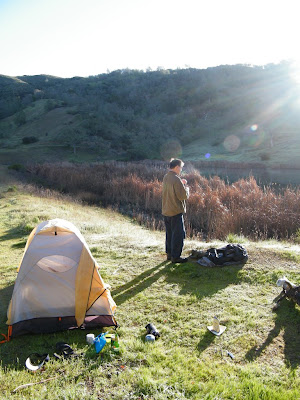
I climbed up into the hills in the early morning hours and snapped this shot of our camp.


Morning sun breaking over my tent.


Steve soaks up the golden hours.


One of several species of duck that call Kelly Lake home.


A nice close up of a flower.


Steve looking like Tom Sawyer with his fishing rod and apple.


Our water fill up spot.


After a relaxing morning sleeping, eating, taking photos and fishing we packed up for the return trip.

Looking east into the Henry Coe backcountry from Kelly Lake Trail.


Looking west from Wasno ridge over a wildflower meadow.


My favorite shot of the trip. Taken at the junction of Wasno Ridge Road and Kelly Lake Trail.


After yesterday's extreme introduction to the sport of backpacking I was all for the easiest possible option out. We decided to go around Steer Ridge rather than over it, through Grizzly Gulch to the Coyote Creek entrance -- a day-use trailhead 2 miles up the road from Hunting Hollow where we parked. We figured we could at least drop our packs a couple miles early, and drive back for them.

Steve descending through a meadow into Grizzly Gulch.


A big boulder on the way to Grizzly Gulch.


Turns out we got lucky at Coyote Creek entrance and ran into a few mountain bikers who were just finishing their beers and heading out for the day. They gave Steve a ride back to the car while I waited along the road with the gear feeling happily exhausted.

Mileage for day two was just over 4 miles. Elevation gain was about 1,000'.

Thursday, March 12, 2009

Henry Coe State Park - 16 Mile Semi-Loop Through The Narrows

Date: 3/7/2009
Distance: 16 miles
Elevation: 2,500' approximate total gain
Weather: 50s-60s, sunny


Back to Henry Coe State park yet again! This was my fourth trip to Old Man Coe's infinite ranch lands already this year. This time we came seeking a wild adventure through the Narrows, a long, narrow canyon south of Poverty Flats through which the east fork of the Coyote Creek flows. I knew after all of this rain the creek would be flowing strong and I couldn't miss the opportunity to see it this way. There won't be another chance this year unless we get another week of heavy rain. As it was conditions were absolutely perfect. It would have been impassible a couple of days prior (during and immediately after the rain) and a couple of days later the water levels will already have started to recede.

Our adventure started out just like a typical Mt. Sizer loop. From Coe Ranch headquarters we descended along Corral Trail and Forest Trail to the junction with Poverty Flats Road. From here it's a steep descent along the wide fire road into Poverty Flats campground.


Immediately upon bottoming out at the flats there is a creek crossing. In dryer seasons it's an easy hop skip and jump across the rocks to the other side. On this day it was flowing heavily so we took our shoes off and waded across.


We continued through Poverty Flats, passing the camping area, eventually hitting the turn off for Jackass Trail.


This trail got scorched pretty bad in the Lick Fire a couple of years ago.


Things are springing back to life in the burn zone already.


Indian Paintbrush, my favorite wildflower. I really like this magenta variety.


After the steep, hot trek up Jackass we arrive at the Blue Ridge. Instead of taking the ridge north towards Mount Sizer, we turned right to head south down into the canyon.


Some nice meadows of Shooting Stars are starting.


A couple miles of downhill on Blue Ridge and we reach our destination, the Narrows! We swap our shoes for our sandals and set off.


There are no trail markers for the Narrows, just follow the Coyote Creek.


Coe creeks are always great for finding animal remains. Anyone lose a femur?


There were lots of these yellow flowers throughout the hike. Anyone know what they're called?


The Narrows offers opportunities for bouldering...


...and tree yoga!


From where we entered the at Blue Ridge Road, to the junction with Willow Ridge Trail, the Narrows was dry enough that one could stay dry with a little effort. From Willow Ridge Trail to China Hole things quickly got deeper and all bets were off.

I took this last cool shot before we had to seal our cameras away for the deepest parts.


By the time we reached China Hole the water was over three feet deep and getting deeper. After several miles of walking through rocky water our feet had enough. We decided to cut north out of the canyon along the middle fork of the Coyote Creek, back up to Poverty Flats Road for the return trip.

When doing a loop from Coe Ranch HQ you always have a climb at the end, since HQ sits on a high ridge. This can often be a very painful thing indeed, but today we barely noticed our 3.5 mile climb out. Maybe it was the added resistance of walking through water that made us feel that much lighter when we hit dry ground. Maybe it was just feeling so damn good from one of the most stunningly beautiful hikes ever. Either way, we ascended back to HQ on angels wings, cracked a beer and watched the late afternoon sun start its slow sink behind the Diablo mountain range.

One to remember for a long time.

Monday, March 9, 2009

Cruisin' to Santa Cruz - A Day of Lots of Driving and Very Little Hiking in the Santa Cruz Mountains

I had some errands down in Santa Cruz the other day. Rather than do the out-and-back drive down Highway 17, I decided to make a long loop of it and enjoy the drive through the northern Santa Cruz Mountains and down along the coast. I had some roads and trailheads I wanted to scout out in San Mateo County, and this was a perfect opportunity.


From Mountain View I went up 280 N to the Sandhill Road exit. Exiting west on Sandhill I continued to Portola Rd. where I (mistakenly) turned left. After passing through the idyllic little town of Portola Valley and its many equestrian facilities, I reached Windy Hill OSP. I've been wanting to scout this trailhead out anyway, and had to use the bathroom, so I hopped out for a look around.

I did a quick scouting of the first couple of trail junctions, and snapped a few pictures of the flora.


Things are very green after all this rain!


By now I knew I had gone the wrong way on Portola Rd., so I reversed course out of the Windy Hill parking lot. I headed back on Portola, passing Sandhill where I made my wrong turn, and not too long after that, La Honda Rd. where I turned left.

La Honda was a pretty drive, up and up and away into the mountains.


From La Honda I went left onto Pescadero Rd., following signs for Sam McDonald County Park. This is one I've been wanting to scout, since it connects into Pescadero Creek County Park, which connects to Portola Redwoods State Park. From Portola Redwoods one can hike the entire northern Santa Cruz range. Heading north to Skyline Blvd would take you to the spine of the range and Black Mountain (the highest peak in the north half of the range). Hiking east would take you to Castle Roack state park. Going south would take you into a vast expanse of coastal ridges comprising Big Basin State Park, Butano State Park, Ano Nuevo State Park before finally reaching the mighty, majestic Pacific Ocean.


Long story short, Sam McDonald connects you to a lot of interconnected prime hiking lands. The parking lot was plenty big enough for a group hike, fees are $5 per car and hours are 8 - sunset.

Some really nice maps of the entire region can be found here:
http://www.redwoodhikes.com/Store/home.html

I still had many miles to go so I decided not to stick around and hike. I kept motoring down the road, shortly passing San Mateo Memorial Park along the way. As I got closer and closer to Highway 1 the deep dark mountains of the redwood forests gradually opened up to rolling coastal hills.

Passing through the small farming town of Pescardero I saw the goat farm on my right. I was tempted to stop and get some cheese and pet some goats, but I kept moving.

I did make myself pull over and stop when I saw a trailhead for Pescadero Marsh. This was a primitive parking lot with no other cars, just a warning sign and a dilapidated wooden sign board. Any messages that were once on the wooden sign have long since faded or disintegrated. Next to it is a narrow little trail into the marsh, which I take.


Something about being that close to where the primordial underwater world meets terra firma really spooks me. What sorts of things might slither up and bite or sting me? Worse, what if some ancient evil reaches up to pull me down to a dark, watery grave, never to be heard from again? I'd rather be mauled by a mountain lion any day. Fortunately none of that happened and I'm here to report about it. I did venture out several hundred yards before I was surrounded by soup on all sides.


I beat a retreat back to the car and continued down the road. Shortly I realized that I had been to the back entrance of the marsh, when I passed the main entrance, where Pescadero Rd. meets Highway 1. This entrance actually had signs of life, and maybe better hiking opportunities, but I decided to cross over the highway and explore Pescadero State Beach instead.


I wasn't walking away today until I got a shot of the Orange Poppy, California's state flower and a sure sign of spring in the San Francisco bay area. Pescadero State Beach didn't let me down.


I also saw birds...


...seaweed...


...and lots and lots of shellfish...


...of different colors.


Heading south on Highway 1 I pass Ano Nuevo State Park, Big Basin State Park (Rando del Oso entrance) and Wilder Ranch State Park. Wilder Ranch is a favorite mountain biking destination of mine. As a Santa Cruz hiking destination it's not the greatest, but it does connect you into a lot of other lands in downtown Santa Cruz and up into the mountains.

By the time I reached downtown Santa Cruz it was past noon, the time I was originally hoping to be home. I decided to make it quick and keep moving, rather than give into the temptation to hang out and lollygag. The return trip up Highways 17 and 85 was a lot less eventful, but a lot faster than the trip there. The whole drive got a little long by the end, but was worth it for the scouting and exploration, and the cruise along the coast.