Date: 4/2/2009 - 4/5/2009
Distance: 23 miles (approximate)
Elevation: 4,500' total gain (approximate)
Weather: 40s-60s, sunny
For my 31st birthday: a four day, three night backpacking trip in Henry Coe SP! This would be Gina's first ever backpacking trip, and my second (see
Kelly Lake the week before). Coe is absolutely beautiful this time of year and we couldn't have had a better time relaxing together in the wild. One of the best damn birthdays ever.
Day One - Coe HQ to Coit Lake via the Narrows and Willow RidgeWe depart from Coe HQ early Thursday morning, descending via Madrone Soda Springs into the Narrows to pick our way through the East Fork of the Coyote Creek eastward to Willow Ridge. After climbing Willow Ridge we follow the ridgeline south to Coit Lake. Coit is the second largest of the Coe lakes, after Mississippi. Coe lakes were man-made for ranchers to be able to water thirsty cattle. Nowadays the lakes are home to numerous fish and birds. Bass, crappie, redwing blackbirds, wild turkey, and several species of duck are among the many things you are likely to see. Other people, however, are among the things you are unlikely to see.
On with the picture show...
Early morning sun on Pine Ridge.

Misty morning oak trees.

"May these quiet hills bring peace to the souls of those who are seeking."
Sada Coe Robinson, 1953

Gina smiles with the morning sun.

Wild turkeys on the way down to Madrone Soda Springs.

At China Hole, Henry Coe's perennial swimming hole.

Turtle at China Hole.

A technical entrance welcomes us to the Narrows.

Soaking up the magical waters of the Coyote Creek.

Snake in the Narrows.

Looking east through the spires. The water gets deep through here.

So we took the high route up and around.

From the Narrows it was 1.6 miles and 1,400' up to Willow Ridge. From there it was another 3.7 miles along the ridge to Coit Lake.

Coit Lake, our home for the night.

Day one stats (approximate):
Miles: 10
Elevation gain: 2,000'
Day Two - Coit Lake to Willow Ridge Spring via Willow Ridge RoadWaking up with the sun at Coit Lake.

Our site from my fishing spot across the lake.

The reedy banks of Coe lakes abound with Redwing Blackbirds.

Coe lakes are full of bass, crappie and other fish. I've been practicing my casting, but haven't caught anything yet. I'm always crashed out in my tent during the good biting hours.

Goodbye, for now, Coit Lake.

After a relaxing morning of sleeping, fishing and eating at Coit Lake we pack up for the four mile hike to Willow Ridge Spring where we'll make our camp for the second night. Willow Ridge Spring sits on the western face of Willow Ridge and has plenty of great spots that provide complete solitude and beautiful sunsets over the northwestern ridges of Coe. Along the way we stop at two spots that have been on my "must see" list for wildflower season, both pictured below.
Taking a break from our packs to dive into the thick wildflower meadow along the George Milias Trail. This trail on the west face of Willow Ridge is marked with orange tape on the trees.

Looking west through the meadow toward Mahoney Ridge.

Poppies in the mountains.

Perched in the poppies.

We took another break from our packs at the Hoover Lake airstrip. The big metal cross was to guide planes to the landing strip next to it.

Because the land in the airstrip is so compacted, these golden flowers grow extremely dense through it during spring wildflower season.

Lupine was in full bloom along the hills next to the airstrip.

Gina relaxing in the flowers.

This area was part of a controlled burn conducted by the park last fall.

Gina on the move. Heading north along Willow Ridge.

Gina eating dinner at our new camp site on Willow Ridge.

Me soaking in the golden hours.

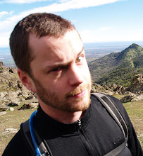
Me watching the sun go down on my 30th year...one of the best yet.

Day two stats (approximate):
Miles: 5
Elevation gain: 1,000'
Day Three - Willow Ridge Spring to China Hole via Willow Ridge Trail and the NarrowsSome breakfast, sunscreen, foot taping and we are good to go. Today we'll head back down the ridge into the Coyote Creek, the way we came. This time we'll stop for afternoon swimming at China Hole, Coe's perennial swimming hole. Tonight we'll enjoy our final night outdoors along the banks of the creek.
Entering a deep section.

I was determined to stay in the water as much as humanly possible without soaking my gear.

I had to bail out and pick my way along the bank at a few points.

After we reached our campsite at China Hole the camera went away while we did some swimming and relaxing. Just one shot of the site.

Day three stats (approximate):
Miles: 3
Elevation gain: 0'
Day Four - China Hole to Coe HQ via China Hole Trail and Manzanita Point RoadThe camera stayed away all day as we focused on putting one foot in front of each other on the climb pack up to Coe HQ on Pine Ridge. After stopping in HQ to chat with the rangers we hopped in our car and winded our way down the mountain road to the valley and the town of Morgan Hill. We roamed the streets of Morgan Hill in search of calories and stumbled on a bar with an all-you-can-eat Mexican brunch. Life is sweet.
Day four stats (approximate):
Miles: 5
Elevation gain: 1,500'